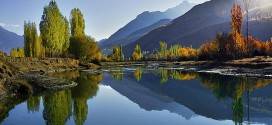
Close to Islamabad in the foothills of the PirPanjal, cool in summer, crisp in winter, the Murree Hills are at an elevation of about 2300 meters (7,500 feet) offer some of Pakistan’s most delightful alpine scenery, which is known as Murree and its Galis around the world.
In the middle of the last century, the British raj (rule) turned it into a hill station and left their own brand of Anglo-Saxon nostalgia indelibly imposed on the local architecture and nomenclature.
They founded this new hill station on the meadows of Mussiari (or Mussidi) village, conveniently close to their military headquarters at Rawalpindi. The local word for high place.Marhi, was anglicized to Murree.

It was the summer headquarters of the Punjab government until 1876 when it was transferred to Simla. Nevertheless, when the road from Murree through Muzaffarabad to Kashmir was completed, it continued to grow in importance. As elsewhere, when far from home, the British built a typical English resort complete with a mall for promenading and ceremonial parades, parks, churches and schools.
Today, the hills are a cool holiday retreat for citizens of Islamabad and Rawalpindi during the sweltering heat of summer. If there’s anything at all of Empire left to savour, it’s the slightly mildewed nostalgia of the old colonialists that arises from Murree’s faded and dilapidated tin-roofed bungalows with names like Primrose Cottage or Woodland Walk and what survives of the resort’s appealing old tea rooms.
Sightseeing:
From Zero Point in Islamabad, the Murree Road crosses a flyover in a north-easterly direction and about fifteen kilometers (nine miles) out comes to a check point; after which, like most things in northern Pakistan, it abandons any pretense to the horizontal and climbs upward, gently at first, then more vertically, into cool, thick pine forest.

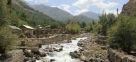
With landslides in summer and snow in winter, there’s a slightly vicarious feel of the Karakorum Highway about it. Less entertaining are the endless convoys of horse and camel drawn traffic and pedestrians, which continuously slow you down, especially in the many little hamlets and villages.
If you have found this all too irksome by the time you reach there, you can u abandon your vehicle if you have a driver, and the idea of Murree and start back on foot along the hills to Islamabad, a delightful if somewhat strenuous walk.
If you continue, however, forty kilometers (25 miles) out of Islamabad, you will arrive at Ghora Gali with, to the right, its Forest Lodge, a cluster of well kept timeserving rest houses owned by the Forestry Department. Even if you don’t stay overnight, the shady gardens make an ideal picnic spot. From the village, there is a road to the left that takes you to Haripur or the Taxila valley.
 c
c
Three kilometers (two miles) beyond the forlorn brew house, the road climbs a ridge to Ghora Gait College. It was originally one of four Lawrence Colleges established for the children of British soldiers serving in the subcontinent. It stands above the lower end of what passes in Murree for The Mall. From the capital, all this should take roughly an hour’s driving.
On along the Mall to, nostalgia again, Sunny Bank, and right into the centre of Murree. Depending on the season, you may have to complete the Mall part of the route on foot.
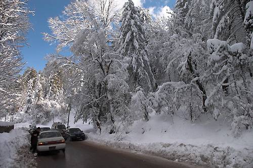
In winter, it is closed to all cars except those residents with a permit. The dubious benefit of which is that, so heavy is the pedestrian congestion, the cars take longer than the walkers take to reach their destination.
The local authority possibly employs an Irish traffic planner, since the one way road system flows in one direction one week and vice-versa the next. Despite this, the accident ratio remains surprisingly low.
The Post Office at the north end of The Mall thus serves as something of a beacon in a sea of confusion and is a good place from which to launch your foot exploration down The Mall and the parallel, lower level Bazaar.
A late afternoon or early evening from ended and gathering along The Mall seems to be the townsfolk’s main social recreation. If you prefer you can undertake this on horse or donkey back.

The Murree (just, near the Post Office is where the Pakistan Constituent Assembly was held in 1955 and if you take a walk to Kashmir Point you’ll discover the holiday homes of many embassies.
Many make Nathiagali their base for walks through the 1or but you can also trek or ride for about eight kilometers (live miles) along the water pipeline from the Pines Motel via Dunga Gali to Ayubia.
A longer trek from the hotel takes you through a lovely meadow to the summit of 2,800 meter high (9,243 feet) Mukshpuri, Or along a track from the Governor’s house to the crest of 2,960 meter high (9,700 feet) Miranjani, A walk of about two hours.

Many continue, both walking and riding, from this summit to Thandiani, staying overnight at a forestry rest house.
The road journey from Murree to Nathiagali takes an hour. It is another hour to climb from Nathiagali to Abbottabad, down steep but beautiful valleys to where the river rushes through a precipitous gorge. There is a turn right to Thandiani thirty kilometers (19 miles) from Nathiagali.
If you travel upwards to Murree, you will reach Ayubia and Bhurban which are the finest spots along with scenic views, you can also find Chairlift and cable cars in Ayubia and Nathiagali which you can memorize for the life time.